


For the 280 million people from 11 countries who live along the banks of the Nile, it symbolises life. For Ethiopia, a new dam holds the promise of much-needed electricity; for Egypt, the fear of a devastating water crisis.
Large hydroelectric dams are touted as a green source of electricity, but they can leave a trail of environmental damage and water insecurity. In this interactive scientific report, Al Jazeera partnered with earth and space scientist Dr Essam Heggy to analyse the impact of large dams on the Nile as the Grand Ethiopian Renaissance Dam (GERD) nears its completion date in 2023. The mega-dam has triggered a major dispute between Egypt and Ethiopia over access to the Nile’s vital water resources. How much will each country get and who controls the flow?
The Nile Delta – Egypt’s food basket

This green triangle in the north of Egypt is the Nile Delta. The lush area was formed in ancient times by the accumulation of silt brought downstream along the River Nile. North to south, the Delta measures 161km and covers the Egyptian coastline from Alexandria in the west to Port Said in the east. It is one of the largest deltas on Earth and is home to more than 40 million people. About half of Egypt’s agricultural produce comes from this fertile area. However, scientists have warned that Egypt’s largest food basket is under threat. In 1971, more than 750km to the south, Egypt inaugurated the Aswan High Dam. It generated around half of Egypt’s electrical power at the time, but this mega-dam also triggered the gradual decline of the Delta’s ecosystem.
Dams, especially the ones with large reservoirs, interrupt the natural cycle of flooding that distributes organically rich silt on river banks, enriching the arable land available, and contributing to the rhythms of the native ecosystem. The sediment held back by the large reservoirs also helps build up the Delta and, without it, erosion has resulted in an accelerated intrusion of sea water from the Mediterranean into the Delta, effectively destroying once-fertile farmland. Today, with the construction of the Ethiopian Renaissance Dam, scientists are warning that a further disruption to the Nile’s ecosystem could cause irreversible damage to the region.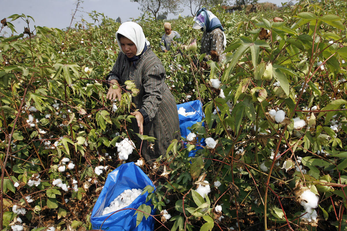

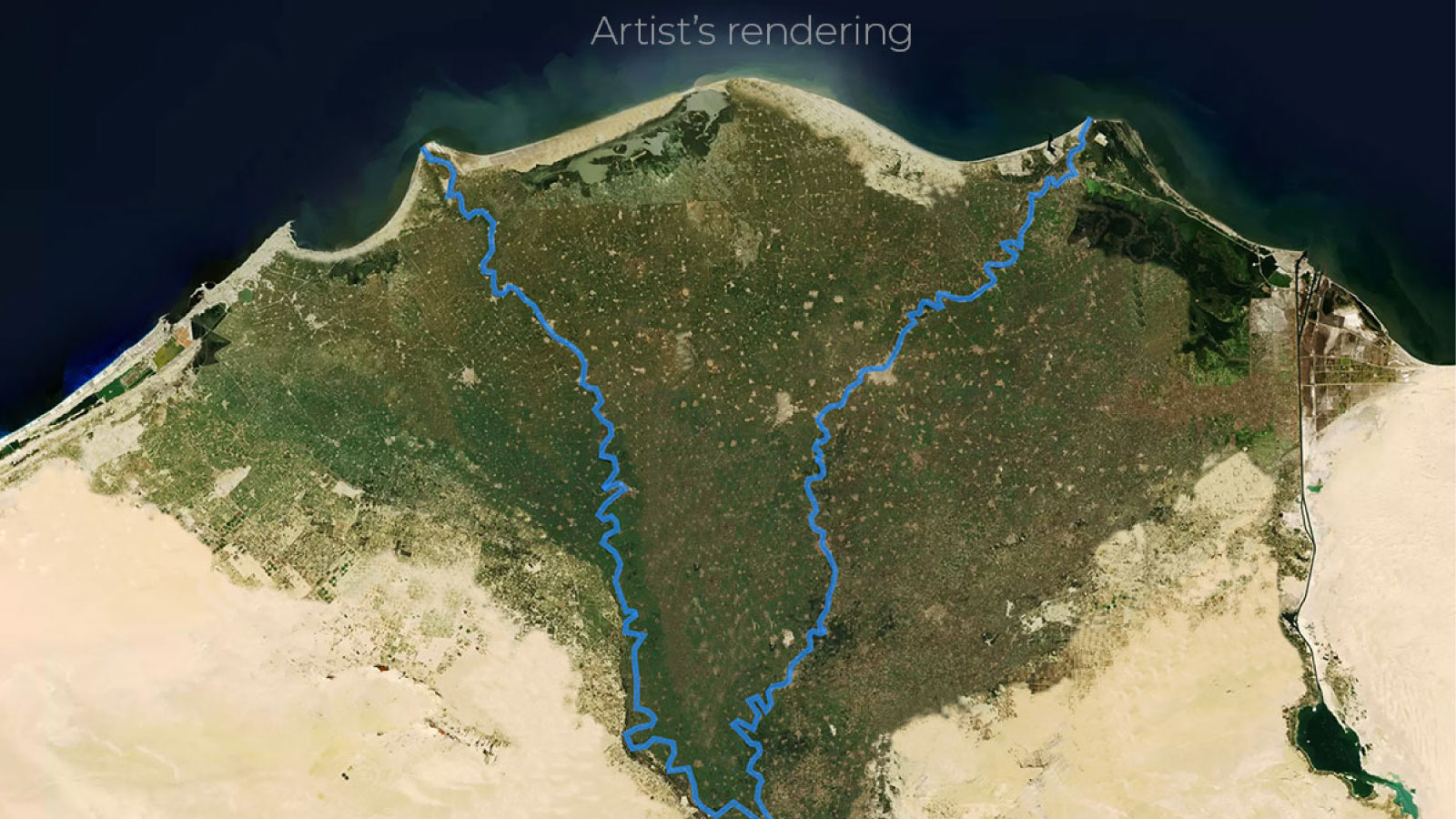
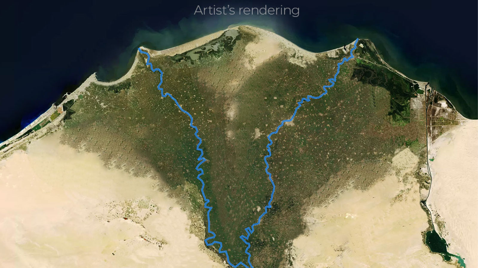
A visual analysis of Egypt’s pending water crisis
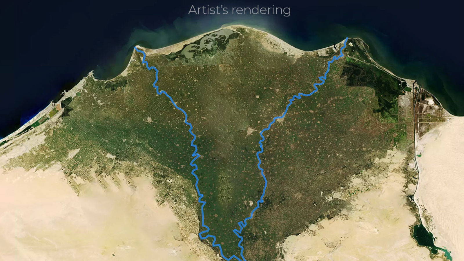
Al Jazeera analysed five scenarios currently being negotiated between Egypt, Sudan and Ethiopia. The scenarios, which are based on academic research, highlight what could happen to Egypt’s annual water reserves and agricultural areas depending on how quickly Ethiopia fills the dam (21, 10, 7, 5 or 3 years). The time it takes to fill the dam has a direct impact on how much water will make it downstream into Egypt. The shorter the time, the lower the flow. Artists’ renderings provide a glimpse of how much of Egypt’s agricultural land could potentially be lost to drought and desertification.
If the Dam is filled in 21 years
In the best-case scenario for Egypt, if Ethiopia fills the Renaissance Dam over the course of 21 years, Egypt’s water deficit is expected to increase by 3 billion cubic metres annually, or approximately 5% of the country’s annual share of the river. A part of this deficit is expected to be filled using Egypt’s groundwater resulting in a loss of less than 2.5% of Egypt’s agricultural area.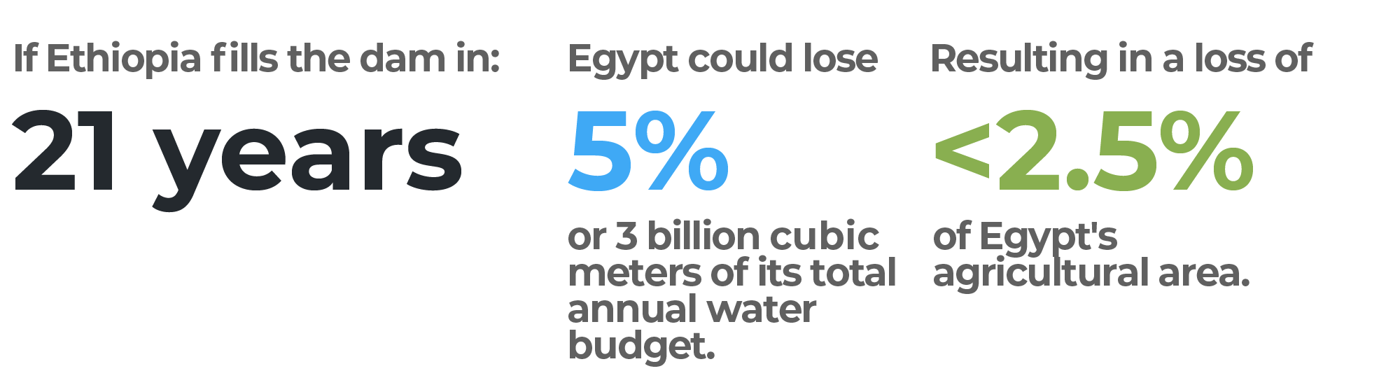

before
after
If the Dam is filled in 10 years
If Ethiopia decides to fill the Renaissance Dam over the course of 10 years, Egypt’s water deficit is expected to increase by 8 billion cubic metres annually, or approximately 14% of the country’s annual share of the river. Nearly two million acres (about 8094 km2) or about 18% of Egypt’s agricultural lands could be lost.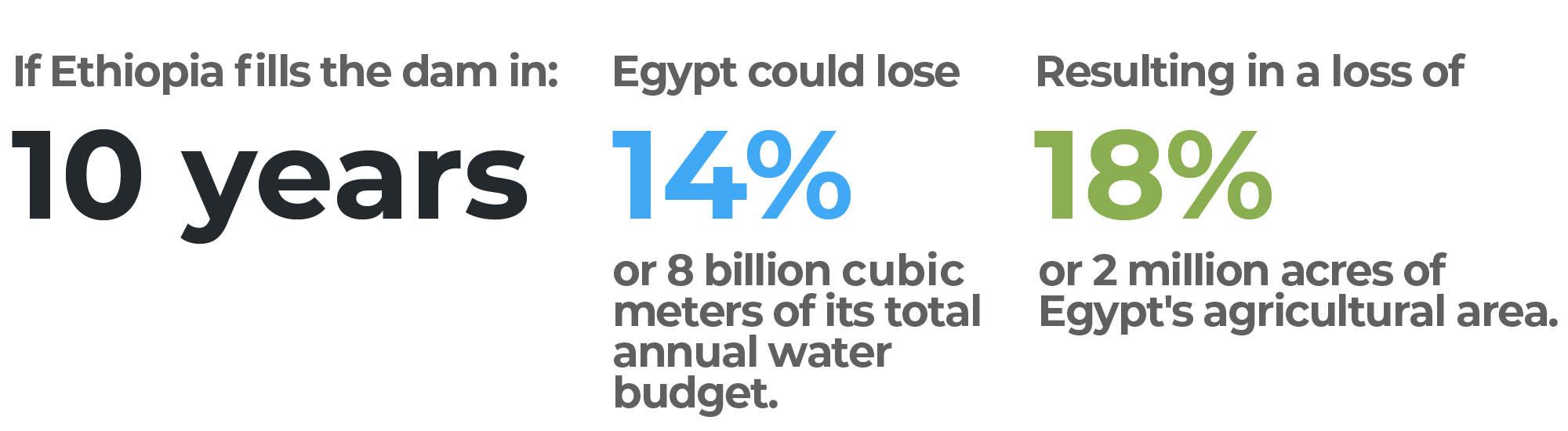

before
after
If the Dam is filled in seven years
Should Ethiopia fill the Renaissance Dam over the course of seven years, Egypt’s water deficit is expected to increase by 12 billion cubic metres annually, or approximately 22% of the country’s annual share of the river. Approximately three million acres (about 12140sq kilometres) or about 30% of Egypt’s agricultural area could be lost.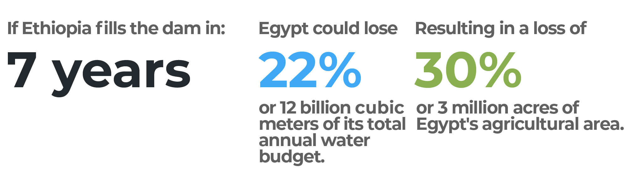
before
after
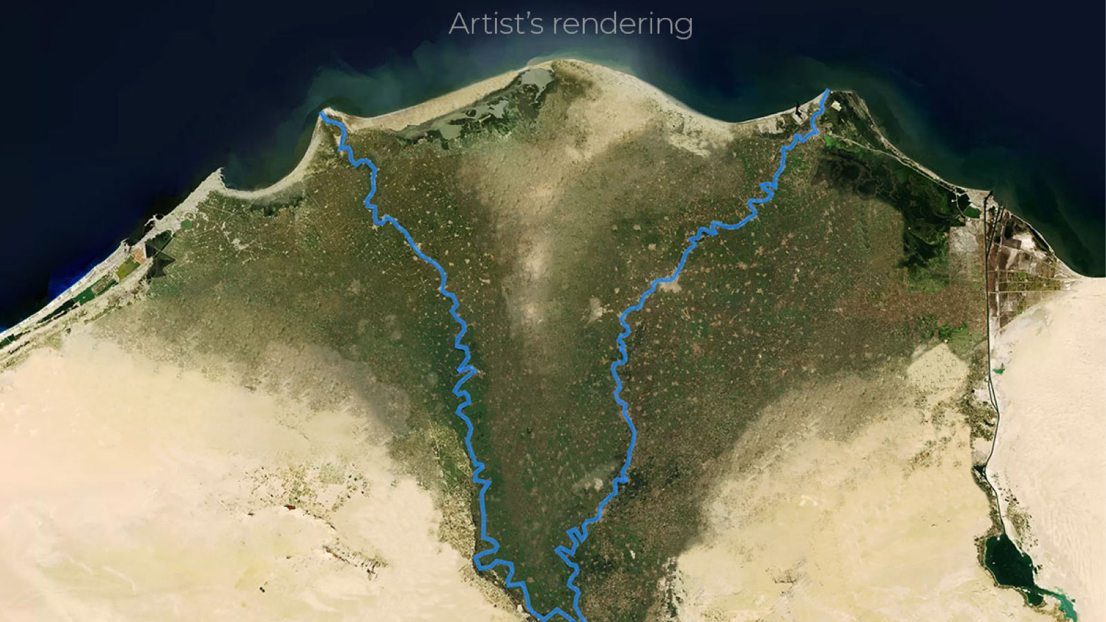
If the Dam is filled in five years
Filling the dam over five years would have yet more extreme consequences for Egypt. It could lose up to 20 billion cubic metres annually, or approximately 36% of its water share. Five million acres (20234sq kilometres), which is about half of Egypt’s total agricultural area, could be lost.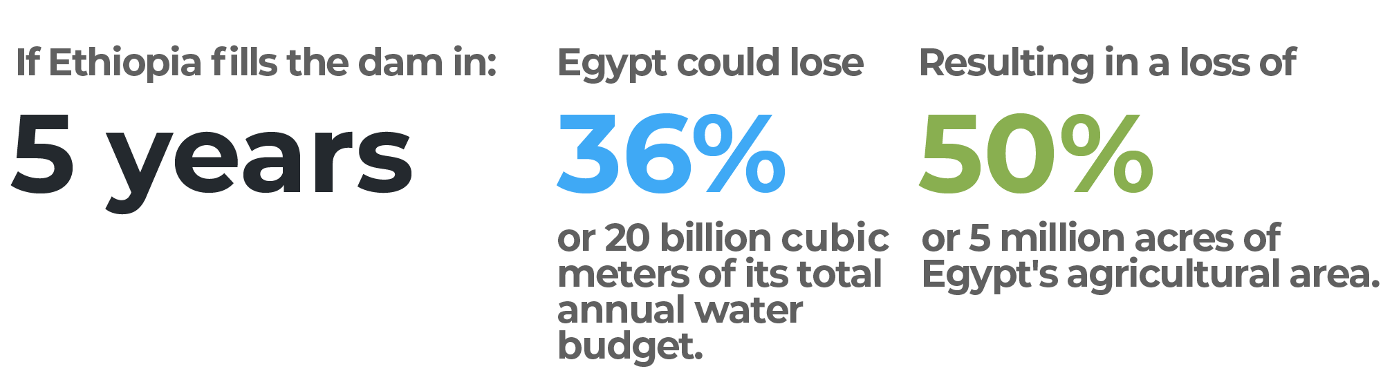

before
after
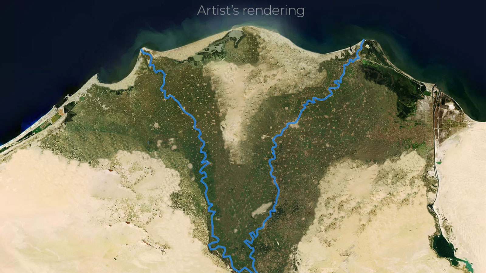
If the Dam is filled in three years
Of the five scenarios, filling the Renaissance Dam over the course of three years would have the most severe consequences for Egypt. It could lose up to 27 billion cubic metres annually, or approximately 50% of its water share. 6.75 million acres (20234sq kilometres) or about 67% percent of Egypt’s agricultural area could be lost.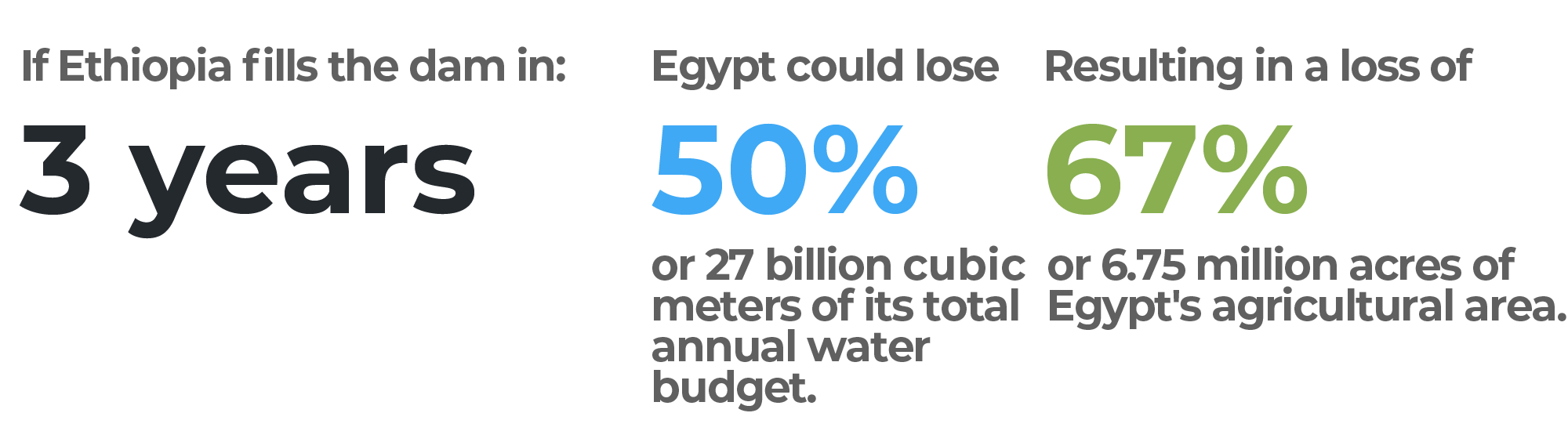

before
after
A JOURNEY UP THE NILE
A river that crosses the desert
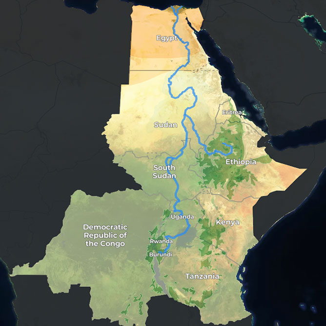
The Nile flows from south to north over 6,695km from its first tributary – the Ruvyironza River in Burundi – before emptying into the Mediterranean Sea. The Nile Basin, which is a network of connected ecosystems, spans 11 countries: Burundi, Rwanda, Tanzania, Kenya, the Democratic Republic of the Congo, Uganda, Ethiopia, Eritrea, South Sudan, Sudan and Egypt. The river consists of two main tributaries known as the White Nile and the Blue Nile. These rivers meet at the Sudanese capital, Khartoum. From there, the unified river is joined by the Atbarah River before reaching Egypt in the north. The Nile is the only river that crosses through five distinct climate zones. The map shows how the river crosses from a tropical rainy climate to a semi-tropical one, then on to a semi-arid climate before the arid Sahara Desert and finally into the Mediterranean.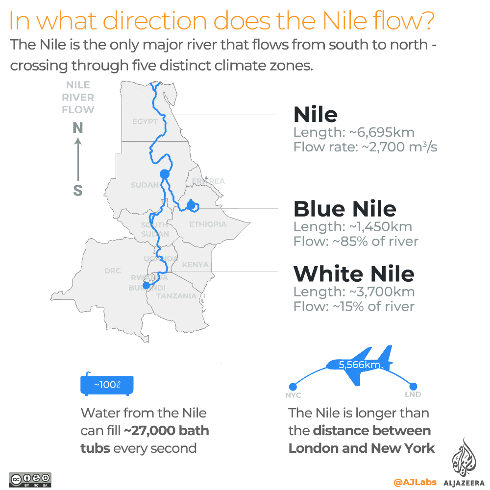
Slow and steady
Scientists believe the Nile to be between 20 and 30 million years old. In its current form, it is considered the oldest and longest river on the planet. It contains more than 100 islands, Egypt being home to 22 of them. The construction of dams on the Nile, including the Renaissance Dam, is expected to severely impact the biodiversity of these islands and the people who rely on them. Although the river is long, compared to other major rivers it is considered very slow. It is estimated to take up to three months for water to flow from Lake Victoria in the south to the Mediterranean Sea in the north. The infographic below compares the flow rates of the Nile with the Amazon and the Mississippi.
Colonial-era treaties
In 1929, Egypt and Britain signed the Nile Waters Agreement. Britain signed as a representative of Uganda, Kenya, Tanganyika (now Tanzania) and Sudan. The document recognised Egypt’s right to the waters of the Nile as well as the right to veto any irrigation projects that would affect its share of the river’s water. In 1959, Egypt and Sudan signed another accord that supplemented the previous agreement. It gave Egypt the right to an annual share of 55.5 billion cubic metres (66%) and Sudan 18.5bn cubic metres (22%). Ethiopia was not consulted. The remaining 12 percent of the river’s 84 billion cubic metre annual water supply is lost to evaporation. Britain benefitted from the agreement as it was, at the time, taking advantage of Egypt’s water-intensive crops, including cotton. In 1999, 10 Nile Basin countries formed the Nile Basin Initiative, namely Burundi, the Democratic Republic of the Congo, Egypt, Ethiopia, Kenya, Rwanda, South Sudan, Sudan, Tanzania and Uganda. This intergovernmental partnership aimed to develop cooperation, share socioeconomic benefits, and promote regional peace and security.
Water resource for 280 million people
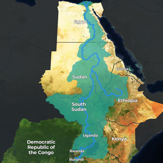
The Nile Basin is shared by 280 million people across 11 countries. The basin is one of the largest in the world, covering approximately 10% of the entire African continent. Despite this, many countries in the region face a water deficit. Growing populations, economic development and climate change have placed additional strains on water resources. The infographic below highlights the number of people who live in the Nile Basin as a ratio of each country’s population.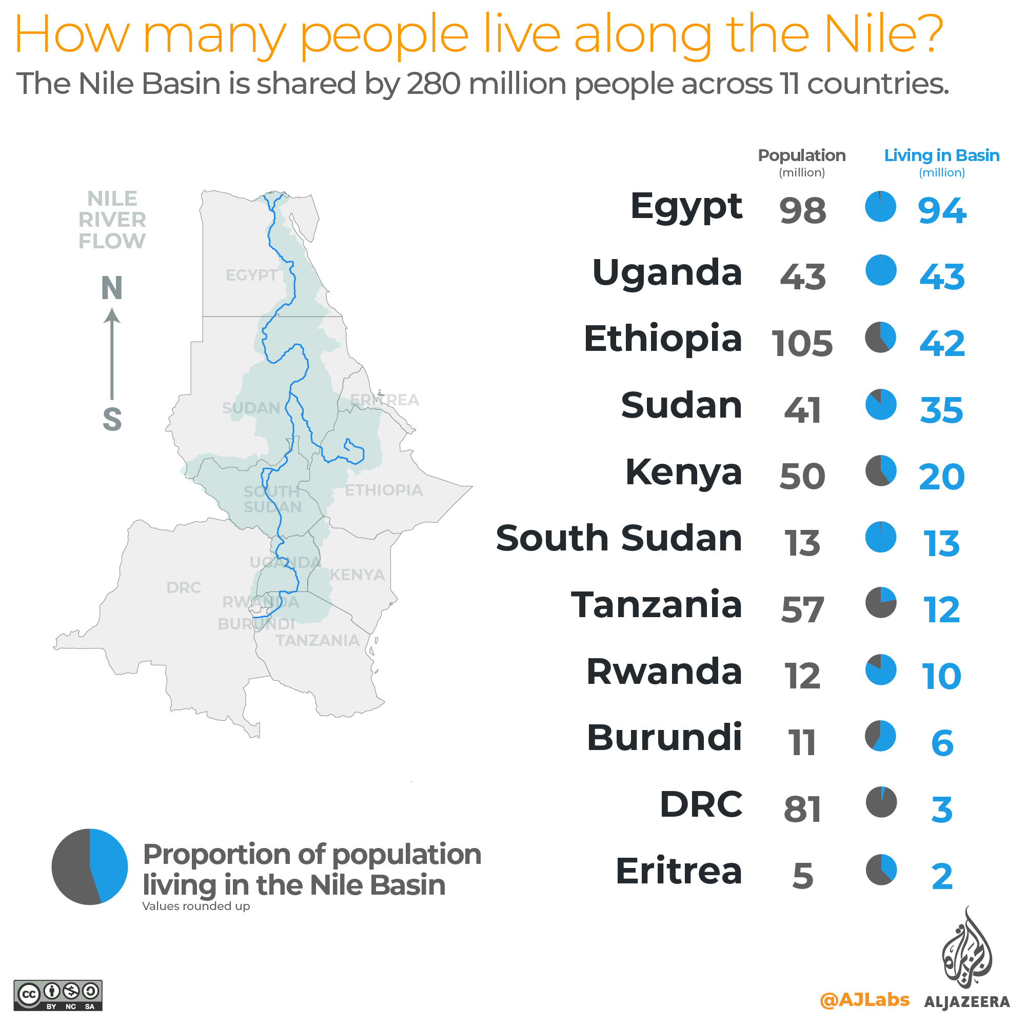
The world’s rivers
The map below shows the world’s major rivers. If you look closely, you will see that the Nile is the only river that flows through the Sahara Desert into Egypt. Only 2% of Egypt’s water comes from inside Egypt. Ethiopia, on the other hand, is home to several river sources, including the Blue Nile. It generates 100 percent of its own water.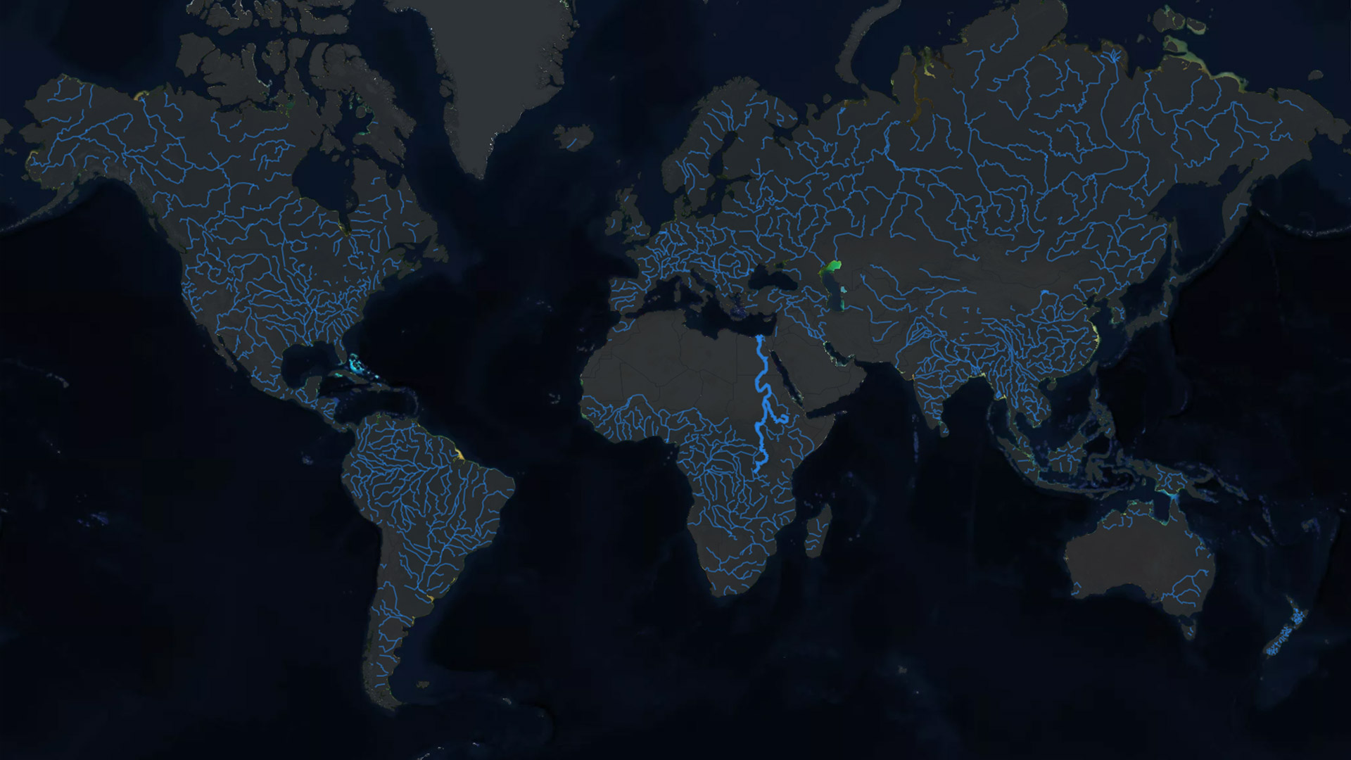 River data: Natural Earth
Is your country self-sufficient in water?
A value of 0% means NONE of your country’s water supply originates within its borders, – 100% means ALL of it does.
https://interactive.aljazeera.com/aje/2020/saving-the-nile/flourish/flourish.html
From Ethiopia to Egypt: United by the Nile, separated by the dam
In the next section we take you along the Blue Nile, beginning at its origins in Ethiopia, passing through the site of the Renaissance Dam, to where it meets the White Nile in Sudan and finally into Egypt.
ETHIOPIA
The source of the Blue Nile
Lake Tana
Lake Tana is the main reservoir of the Blue Nile, providing over 80 percent of the river’s water. It is located 1,788 metres above sea level in the northwestern Ethiopian Highlands. Lake Tana is Ethiopia’s largest lake (the third-largest in the Nile Basin) and contains half the country’s fresh water resources. Seven large permanent rivers, as well as about 40 smaller seasonal rivers, feed the lake.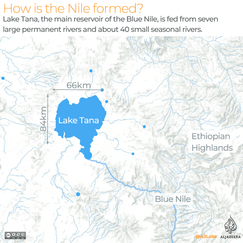
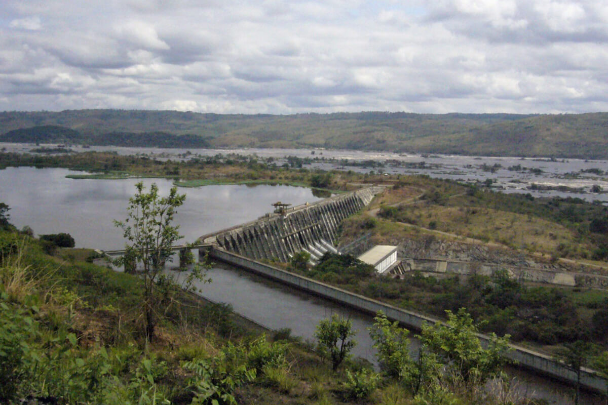
The Renaissance Dam
Ethiopia began construction of the Renaissance Dam in April 2011. The twin-reservoir dam is in the Benishangul-Gumuz region, just 30km from the Sudanese border. Once complete, the primary dam will span an area of 1,780sq kilometres and will store approximately 15 billion cubic metres of water behind its 155 metre-high wall. The second auxiliary dam is a rock and concrete reservoir, measuring 4,800 metres in length and 55 metres in height. It will store approximately 60 billion cubic metres of water and will help divert any excess water from the primary reservoir back along the course of the Nile. The dam has a combined capacity of almost 75 billion cubic metres.
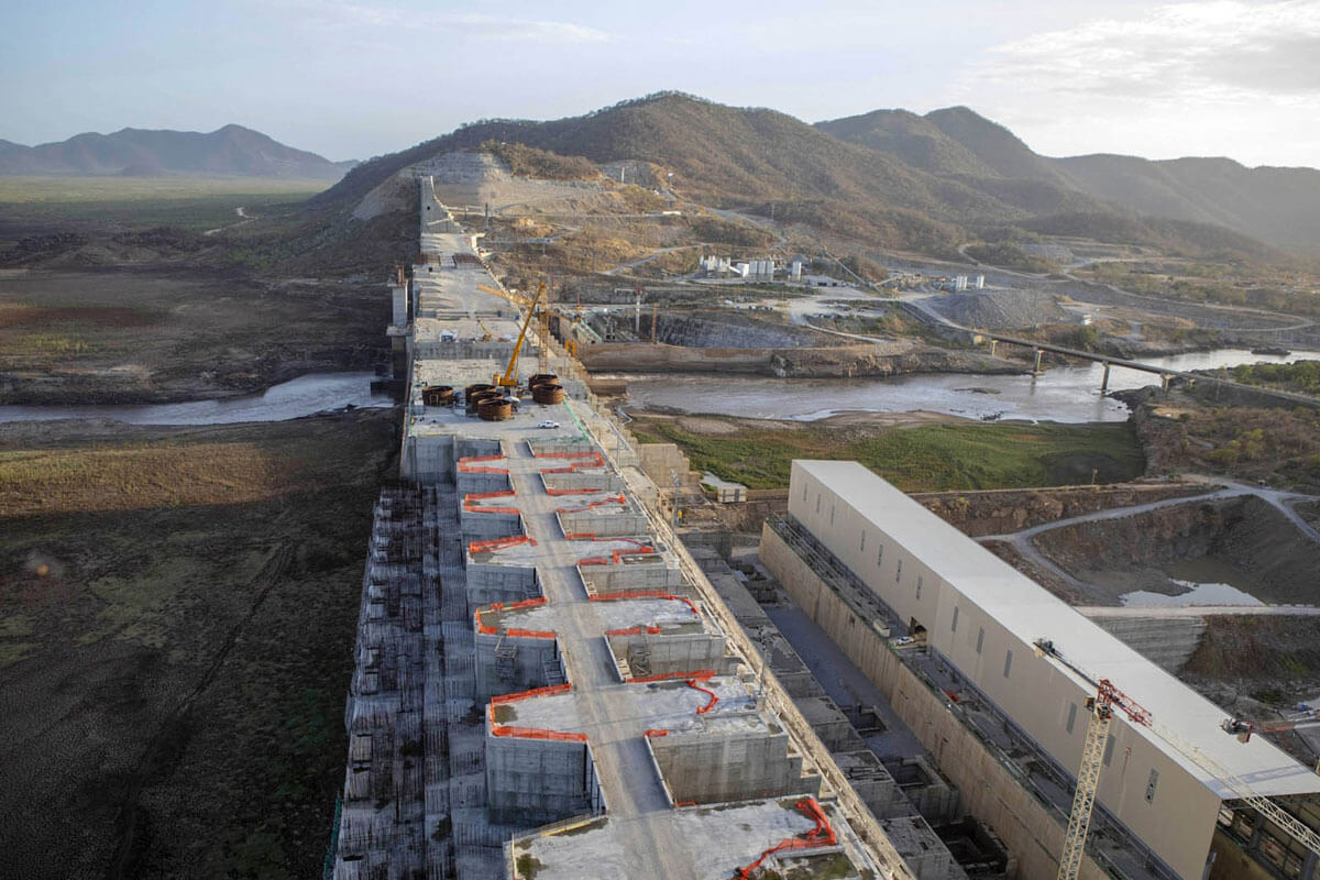

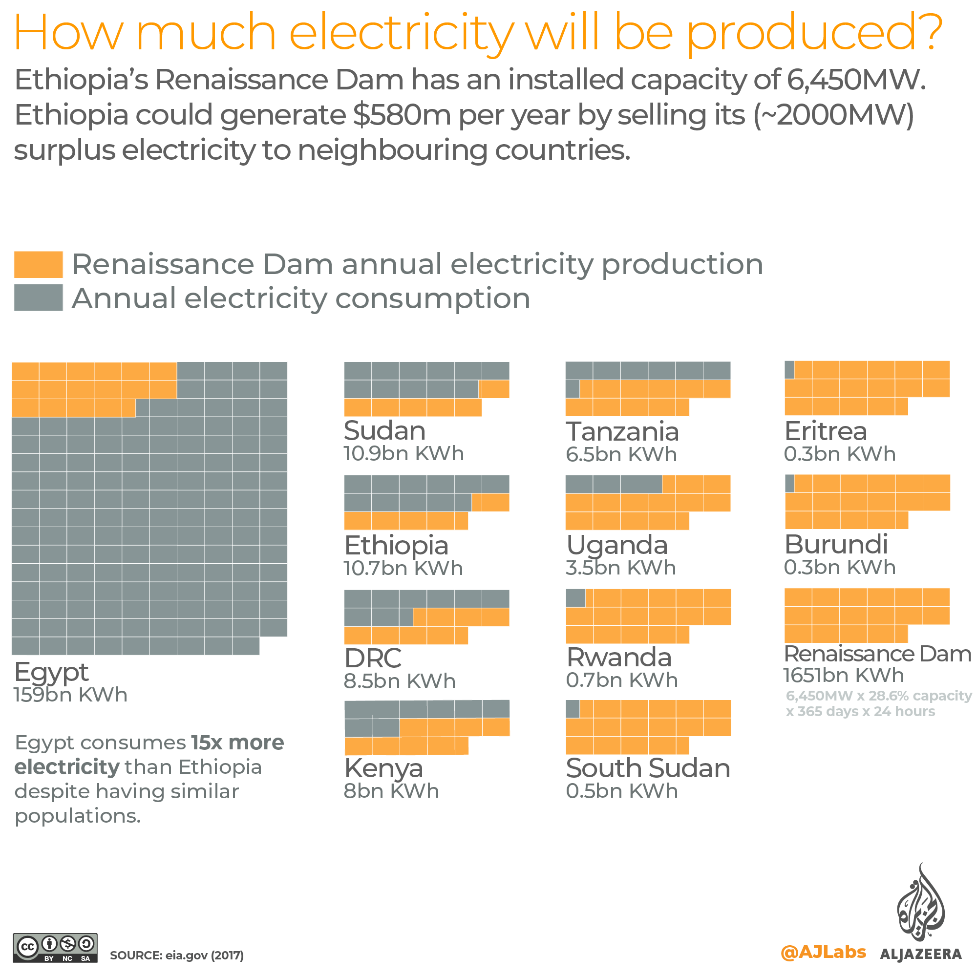
Egypt’s Aswan High Dam has more than twice the volumetric capacity of the Renaissance Dam. Once complete, the Renaissance Dam will be the second-largest dam in Africa by volume. However, in terms of electricity produced, the Renaissance Dam’s 6,450MW rating will easily eclipse the Aswan High Dam’s 2,100MW rating, making it the largest hydroelectric power plant on the African continent and among the top 10 in the world. On November 13, 2019, Ethiopia announced that it had completed construction of the auxiliary dam. The main dam is expected to be completed in early 2023 but will begin filling in the summer of 2020. Here is how Ethiopia’s Renaissance Dam stacks up against Egypt’s Aswan High Dam, as well as a breakdown of how much electricity it is expected to produce.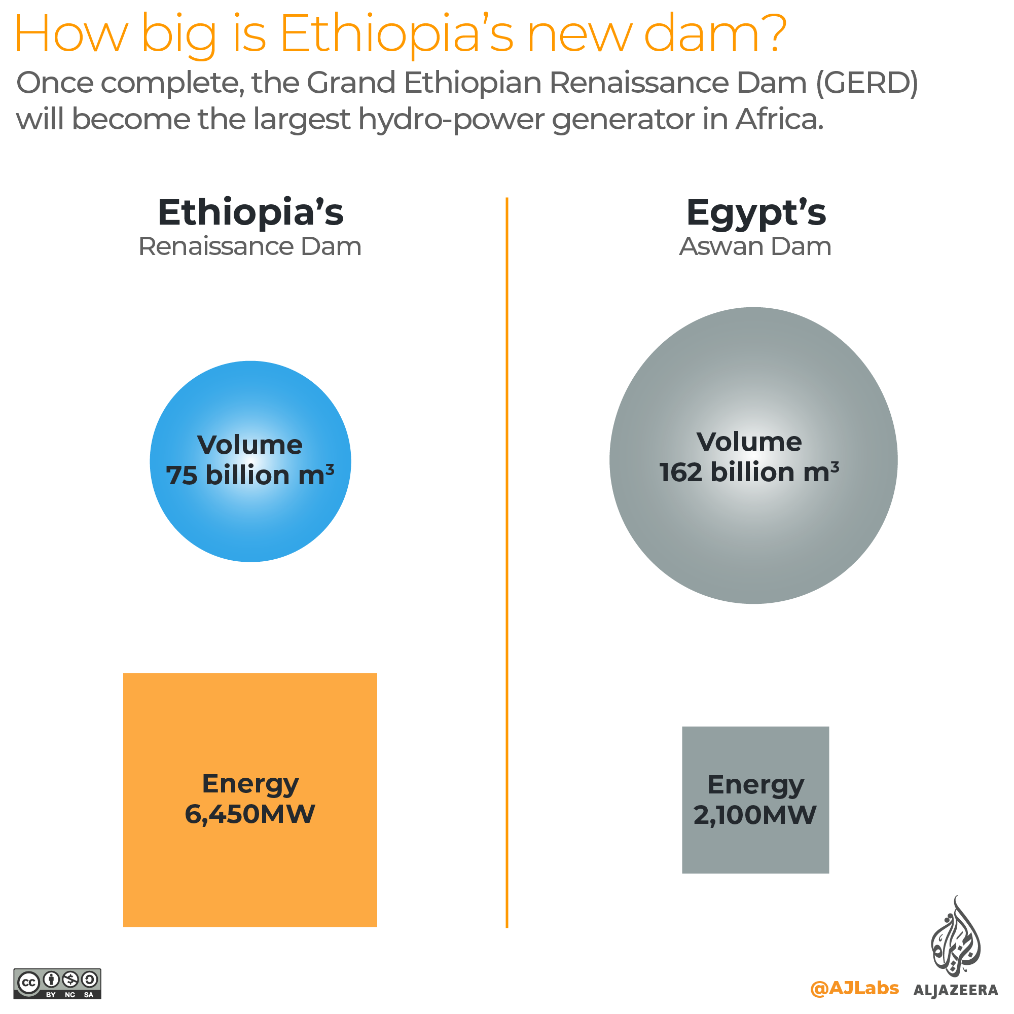
The world’s power plants
The map below shows the locations of roughly 30,000 power plants around the world. China, the US and India consume more electricity than the rest of the world combined.
Fossil Fuels Hydro Nuclear Wind Solar Geothermal Other Power Plant Database: World Resources Institute
How much electricity does your country consume annually?
https://interactive.aljazeera.com/aje/2020/saving-the-nile/flourish2/flourish.html
What Ethiopia wants
The East African country is counting on the Renaissance Dam to meet its growing energy and development needs. The Ethiopian government is planning to build a new commercial network in surrounding areas, which it says will lead to employment opportunities. Once the dam is complete, Ethiopia will become Africa’s largest energy exporter, and sell about 2,000MW of surplus electricity from the dam to neighbouring countries. Addis Ababa refuses to acknowledge colonial-era Nile Water Agreements and wants the dam to be filled in three to five years. It believes the 40 billion cubic metres of dam water that Egypt says it needs annually will hinder its ability to fill the dam in time to produce much-needed electricity. Ethiopia is one of the cleanest energy producers on the African continent. The following infographic illustrates how Ethiopia generates its electricity compared with the rest of the continent.
The world’s clean energy
The map below shows the locations of around 30,000 clean and non-clean power plants around the world. Clean energy comprises zero-carbon sources such as hydro, wind, solar and nuclear. Non-clean sources include coal, oil and gas.
Non-clean energy Clean Energy Power Plant Database: World Resources Institute
How much of your country’s electricity comes from clean energy sources?
https://interactive.aljazeera.com/aje/2020/saving-the-nile/flourish3/flourish.html
SUDAN
Where the two rivers meet
The triangle capital

The White Nile and the Blue Nile join one another forming a triangle around Sudan’s capital city Khartoum. From there, the unified river will flow another 2,500 km before reaching the Mediterranean Sea.
What Sudan wants
Khartoum, like Cairo, is concerned about its share of the Nile’s water. Experts believe that the construction of the dam could bring some benefits to the country, most notably regulating the flow of the Nile throughout the year, which could increase agricultural output and prevent devastating flooding. The dam will also block large amounts of silt and tree trunks that obstruct the turbines of Sudan’s own hydroelectric dams in the east of the country. However, experts have warned that this reduction of silt will impoverish Sudan’s fertile land, making it more difficult for the country to achieve food security.
EGYPT
Livelihood for millions
Egyptian Civilization
For more than 5,000 years, civilisations have thrived along the banks of the Nile. Ancient Egyptians revered the mighty river, calling it a “gift of the gods”. Historians attribute Egypt’s social, cultural and political foundations to the river. Today, the Nile still provides 98% of Egypt’s water needs, with about 95% of Egyptians living on its banks.
The High Dam, an expensive solution
Inaugurated in 1971, Egypt’s Aswan Dam is Africa’s largest by volume. It produces 2,100MW of hydroelectric power, which accounts for less than 5% of Egypt’s total energy production. Scientists have warned that the dam has had a negative environmental and biological impact on the northern part of Egypt’s Delta, including erosion of the coast. Prior to the construction of the dam, the Nile in Egypt contained more than 72 species of widely present fish. Today, less than 25 species remain.

What Egypt wants
Egypt wants to ensure that its 55.5 billion cubic-metre share of the Nile is not reduced. Egypt wants Ethiopia to fill the dam over the course of 10 to 21 years and only during the rainy season. Cairo has also demanded that Addis Ababa double the number of water release points in the dam to ensure adequate water flow when water levels are low.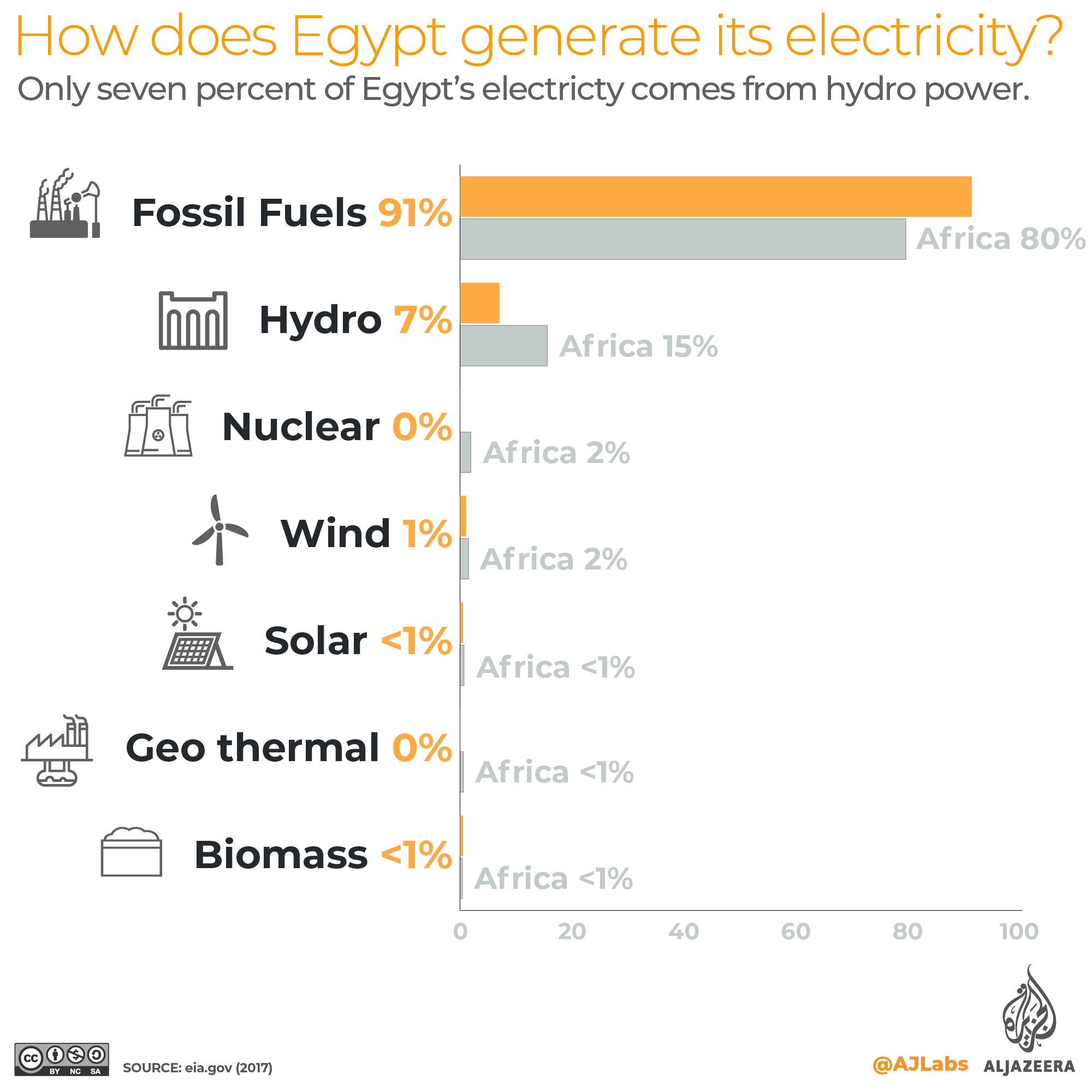
Can Egypt avoid a water crisis?
While there are a handful of solutions available to Egypt, most of them will mean substantial costs to Egypt’s energy, water and food production. The infographic below outlines the most practical steps Egypt can follow to avoid an all-out water crisis.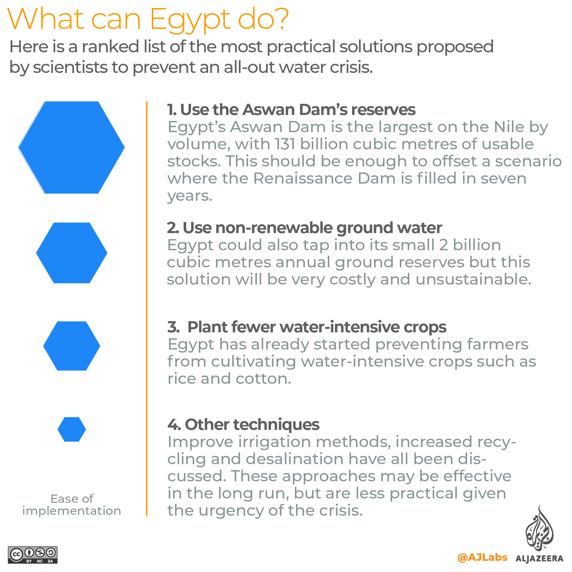
THE FUTURE
Water v Electricity
More dams on the Nile
Over the past 50 years, six Nile Basin countries have built 25 hydroelectric dams. As of 2019, four dams were under construction with four more being studied. The Nile is not just a source of water. It is an exceedingly sensitive ecosystem that plays a role in the environmental and ecological balance of east Africa. The Nile is home to more than 800 species of fish. The diversity of fish stocks is linked to the diversity of birds, insects and microorganisms. The absence of any of these elements will undermine the entire ecosystem. Any disruption to the quality and volume of the water flowing through the river has an impact on the people and wildlife who depend upon it and could trigger a wide-scale extinction.
© 2020 Al Jazeera Media Network.
This project was supervised under Dr. Essam Heggy.
Developed by: Mohammed Haddad Editors: Mohammed Haddad, Zouhaier Hamdani, Mohamed ElAli, Moawia Al Zubair, Carla Bower, Hala Saadani Producers: Heba Hafez Video Editors: Seena Khalil, Khaldun Abusnaina
References
- Ecological Implications of River Flow Modification: Impacts on Riparian Vegetation in the Upper part of Blue Nile Basin, North Western Ethiopia – Paperback – August 10, 2010. By M Amare, H Sulaiman H, M McCartney.
- The Nile Basin: Quaternary Geology, Geomorphology and Prehistoric Environments 1st Edition, Cambridge University Press; 1 edition (February 14, 2019). By Martin Williams.
- Grand Ethiopian Renaissance Dam Versus Aswan High Dam. By Negm, Abdelazim, Abdel-Fattah, Sommer.
- The Grand Ethiopian Renaissance Dam on the Blue Nile. By Abtew, Wossenu, Dessu, Shimelis Behailu.
- The Grand Ethiopian Renaissance Dam, its Impact on Egyptian Agriculture and the Potential for Alleviating Water Scarcity. Youssef M. Hamada.
- The Nile Origin, Environments, Limnology and Human Use. By Dumont, Henri J.
- Nile River Basin Ecohydrological Challenges, Climate Change and Hydropolitics. By Melesse, Assefa, Abtew, Wossenu, Setegn, Shimelis Gebriye.
- The Nile River. By Negm, M. Abdelazim.
- The Nile Delta. By Negm, M. Abdelazim.
- Forecasting water budget deficits and groundwater depletion in the main fossil aquifer systems in North Africa and the Arabian Peninsula.


17 thoughts on “Nile: River of 280 Millions”
как найти blacksprut – как зайти на блекспрут, блэкспрут blacksprut
Земля в рассрочку – Инвестиции в недвижимость, Дом в аренду в области
Щиро запрощуємо до нашої студії тату та пірсингу в Житомирі!
Ми робимо чудові шедеври, що підкреслюють вашу індивідуальність та стиль. У нашій в команді працюють досвідчені майстри з багаторічним досвідом, які використовують безпосередньо найновіше інструменти та безпечні матеріали.
Ви мрієте про оригінальне татуювання або стильний пірсинг? У нас ви знайдете все для втілення ваших найсміливіших ідей. Подаруйте собі можливість виділитися з натовпу та висловити свою особистість через мистецтво тату та пірсингу.
Приходьте до нашої студії ГОЛКА та переконайтеся в якості нашої роботи!
Зроби собі подарунок у вигляді Пірсінгу – https://golka.love/
kraken 17at – кракен сайт kr2web in, кракен ссылка
TorZon Market – best darknet shop https://examhelpbox.testing-website.xyz/updated-torzon-market-url-2024-find-the-latest-torzon-market-link-here
очистители грунта – гель для ультразвукового контроля, эталон чувствительности канавочный
блок подготовки воздуха – клапан электромагнитный газовый, купить затворы дисковые поворотные
магнитный держатель для рентгенпленки – ультразвуковой контроль дефектоскопия, магнитная суспензия для магнитопорошкового контроля
At this time I am going away to do my breakfast, once having my breakfast coming yet again to read more news.
please rate my page too
http://forum.changeducation.cn/forum.php?mod=viewthread&tid=638954 – porn for vr
http://www.larktjj.com/forum.php?mod=viewthread&tid=211015 – milf por n
https://justbevictorious.com/friendly-relationship-exposed/ – teennude
http://forum.changeducation.cn/forum.php?mod=viewthread&tid=693830 – live cam masturbating
https://www.ofurea.com/blog/298212/young-woman-friend-the-samurai-fashion/ – milf pegging
=oo3345#
Опираясь на широкий навык в этом деле и профессиональную бригаду профессионалов, по восстановление производительности скважин, промывка скважины, гидродинамическая очистка, прочистка дождевой канализации, установка пьезометрических трубок, очистка резервуаров питьевого водоснабжения, замена СУЗ на скважине, восстановление эксплуатационных характеристик скважины и прочие. Подобные сервисы обширно применяются во всевозможных секторах, таких как сельское хозяйство, ирригация, жилой и коммерческий сектор. Наша команда экспертов обладает в распоряжении 10 летний практический опыт в данных направлениях, что даёт возможность нашей фирме исполнять эти сервисы такие услуги как очистка скважины, очистка канализации, промывка ливневой канализации, замена труб в скважине, монтаж водоподъёмной трубы в скважине, очистка резервуаров питьевого водоснабжения, телеинспекция артезианских скважин, поставка скважинных трублегко и с полной отдачей. Имеющиеся услуги постоянно используются нашими заказчиками за их своевременное совершение и более лучшую ценовую политику.
Ваш лазерный принтера требует перезарядки картриджа? Превратите траты на новые картриджи в экономию с нашей услугой по заправке картриджей лазерных принтеров в Украине!
Наша команда мастеров гарантирует высококачественное обслуживание вашего принтера или МФУ, используя только высококачественные расходные материалы. Забудьте о прерванных печатных заданиях и переплате за новые картриджи – с нами вы экономите свои деньги!
Заправить картридж лазерного принтера – https://printershub.com.ua/ru/zapravka-kartridzha
Не теряйте время и деньги – доверьтесь профессионалам от PrintersHub!
дефектоскопист по ультразвуковому контролю – набор для низкотемпературного капиллярного контроля, проявитель для капиллярного контроля
collection of poems composed
набор маркировочных знаков латиница – кассеты для рентгеновской пленки, очистители грунта
мобильные прокси купить foxyproxy – купить аккаунт вк с друзьями, купить старый аккаунт авито
KMSPico Download https://disk.com/download-kms
Цены в нашем прейскуранте не завышены и они значительно ниже, чем вы сможете найти в Москве и Московской области, к тому же, диагностика и выезд на дом при заказе ремонта не оплачиваются https://zapchasti-remont.ru/shop/podshipniki_i_vtulki/